| CPC G06T 3/4007 (2013.01) [A01D 41/127 (2013.01); G06N 3/047 (2023.01); G06N 3/08 (2013.01); G06Q 10/04 (2013.01); G06Q 50/02 (2013.01); G06T 5/50 (2013.01); G06T 7/0016 (2013.01); G06T 7/143 (2017.01); G06V 10/82 (2022.01); G06V 20/13 (2022.01); G06V 20/188 (2022.01); G06T 2207/10016 (2013.01); G06T 2207/10032 (2013.01); G06T 2207/10048 (2013.01); G06T 2207/20081 (2013.01); G06T 2207/20084 (2013.01); G06T 2207/20221 (2013.01); G06T 2207/30181 (2013.01); G06T 2207/30188 (2013.01); G06V 20/194 (2022.01)] | 20 Claims |

|
1. A method implemented using one or more processors, comprising:
obtaining a first temporal sequence of high-elevation digital images,
wherein the first temporal sequence of high-elevation digital images capture a first geographic area at a first temporal frequency, and
wherein each high-elevation digital image of the first temporal sequence is captured at a first spatial resolution;
obtaining a second temporal sequence of high-elevation digital images,
wherein the second temporal sequence of high-elevation digital images capture the first geographic area at a second temporal frequency that is less than the first temporal frequency, and
wherein each high-elevation digital image of the second temporal sequence is captured at a second spatial resolution that is greater than the first spatial resolution;
selecting a given high-elevation digital image from the first temporal sequence that is captured during a time interval in which no high-elevation digital images of the second temporal sequence are available; and
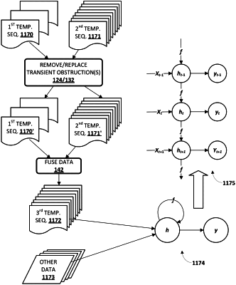
fusing the given high-elevation digital image of the first temporal sequence with data ascertained from one or more high-elevation digital images of the second temporal sequence to generate a synthetic high-elevation digital image of the first geographic area at the second spatial resolution;
including the synthetic high-elevation digital image of the first geographic area as part of a third temporal sequence of high-elevation digital images that capture the first geographic area over a predetermined time interval, wherein the first geographic area includes a first type of crop during the predetermine time interval;
iteratively applying the high-elevation digital images of the third temporal sequence as input across a machine learning model to generate a first output indicative of an estimated crop yield of the first geographic area at the end of the predetermined time interval; and
causing one or more output components of one or more computing devices to audibly or visually convey the estimated crop yield of the first geographic area at the end of the predetermined time interval.
|