| CPC G06T 17/05 (2013.01) [G06F 16/587 (2019.01); G06T 7/593 (2017.01); G06T 15/04 (2013.01); G06T 15/06 (2013.01); G06T 17/20 (2013.01); G06T 2200/24 (2013.01); G06T 2207/10012 (2013.01); G06T 2207/10028 (2013.01); G06T 2207/20221 (2013.01); G06T 2210/21 (2013.01); G06T 2210/56 (2013.01)] | 31 Claims |
|
1. A system for modeling a structure, comprising:
an aerial imagery database; and
a processor in communication with the aerial imagery database, the processor:
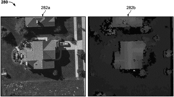
retrieving at least one stereoscopic image pair from the aerial imagery database;
identifying a target image from the at least one stereoscopic image pair;
identifying a reference image from the at least one stereoscopic image pair;
rectifying the target image and the reference image so that principal camera rays of the target image and the reference image are parallel and originate on the same plane;
calculating an optimized disparity value for each pixel of the identified target image by applying a semi-global matching algorithm to minimize a cost measure at corresponding pixel locations between the target image and the reference image;
generating a disparity map based on the optimized disparity values for each pixel of the identified target image;
generating a three dimensional point cloud based on the disparity map; and
generating a three dimensional model of the structure using the three-dimensional point cloud.
|