| CPC G06T 17/00 (2013.01) [G01S 17/89 (2013.01); G06T 15/80 (2013.01); G06V 10/26 (2022.01); G06V 10/751 (2022.01); G06V 20/188 (2022.01); G06V 2201/121 (2022.01)] | 20 Claims |
|
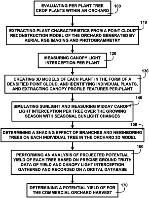
1. A method, comprising:
creating 3D models of an orchard with multiple plants in the form of a densified point cloud using oblique aerial RGB imaging and photogrammetry;
identifying and segmenting individual plants of the orchard from the 3D models;
simulating sunlight radiation of each plant in the 3D models;
determining a shading effect of branches and neighboring plants on each individual plant at any time of the day;
determining canopy light interception of each plant;
extracting and analyzing canopy profile features of each plant in the 3D models;
forecasting potential yield of each plant based on the measured canopy light interception;
calculating nitrogen and water requirements of each plant based on the potential yield and other predetermined field, environmental and climate factors; and
providing a measured actual yield for each plant to validate yield forecasting by canopy light interception data.
|