| CPC G01C 21/3852 (2020.08) [G01C 21/3815 (2020.08); G06T 15/04 (2013.01); G06T 17/05 (2013.01); G06V 10/25 (2022.01); G06V 20/13 (2022.01); G06V 20/176 (2022.01)] | 15 Claims |

|
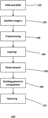
1. A method for 3D geospatial mapping comprising:
providing 2D satellite imagery related to an area of interest for geospatial mapping;
analyzing the satellite imagery to generate a digital surface model (DSM) and a digital elevation model (DEM), wherein the DSM is a surface profile of the area of interest and the DEM is a bare surface profile of the area of interest without protrusions;
preprocessing the satellite imagery to generate a point cloud of the area of interest, wherein preprocessing comprises
removing atmospheric clouds,
removing shadows, and
generating 3D models of buildings in the area of interest;
generating a 3D geographical information system (GIS) map with multiple levels of details (LOD);
layering a road network onto the bare surface profile of the DEM, wherein layering comprises
identifying the road network from the point cloud,
identifying people and cars from the point cloud,
removing the people and cars from the point cloud, and
layering the road network without the people and cars onto the bare surface profile;
computing a geometry of the buildings from the point cloud; and
texturing the GIS map, wherein layering the road network, computing the geometry of the building and texturing are repeated for each LOD.
|