| CPC G05D 1/0011 (2013.01) [B64C 39/024 (2013.01); B64U 50/19 (2023.01); B64U 50/34 (2023.01); B64U 2101/30 (2023.01); B64U 2201/202 (2023.01)] | 29 Claims |
|
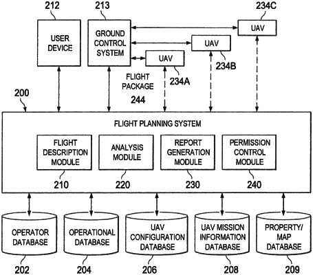
1. A flight system comprising:
one or more processors comprising hardware;
a memory storing instructions that, when executed by the one or more processors, cause the one or more processors to:
receive multiple jobs, each job including a respective flight plan associated with a location for an aerial survey to be performed by an unmanned aerial vehicle (UAV);
display, one or more jobs via a user interface, each job having an associated image of the location where the aerial survey is to be performed and a textual description of the job;
receive, via the user interface, a selection of a job to be performed;
analyze the associated image to determine a home location for the UAV;
receive confirmation that pre-flight checks of the UAV have been performed;
instruct the UAV to autonomously perform the aerial survey, the aerial survey comprising a flight pattern, wherein the flight pattern includes a path from the home location to a starting location, the starting location beginning a path where the UAV periodically obtains sensor information describing a property, land, or other structure;
determine that a contingency event has occurred, the contingency event indicating a loss or degradation of a global positioning satellite (GPS) signal; and
responsive to the contingency event, display, via the user interface, an indication of a physical location of the UAV and instruct the UAV to switch to manual control; or based on a resolution of the contingency event, instruct the UAV to autonomously land at the home location.
|