| CPC G01S 13/951 (2013.01) [G01S 13/958 (2013.01); G01W 1/10 (2013.01); G01W 1/14 (2013.01); G05B 19/042 (2013.01); A01B 79/005 (2013.01); A01G 25/167 (2013.01); G01W 2203/00 (2013.01); G05B 2219/2625 (2013.01); G06Q 50/02 (2013.01); Y02A 90/10 (2018.01)] | 20 Claims |
|
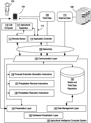
1. A computer-implemented method providing improvements in agricultural science by improving sensor measurements of precipitation, the method comprising:
receiving, from a radar device, one or more digital precipitation records, the one or more digital precipitation records comprising a plurality of digital data values representing precipitation amounts at a plurality of locations, each of the digital data values indicative of a radar-based precipitation amount at a location;
receiving one or more digital forecast records comprising a plurality of digital data values representing precipitation forecasts at the plurality of locations for a plurality of different lead times, for each of the plurality of locations, the data values including forecast values for each of a plurality of incremental intervals, the precipitation forecasts each generated at a different one of the plurality of different lead times, the precipitation forecasts overlapping during at least one of the incremental intervals;
identifying, using the one or more digital precipitation records and the one or more digital forecast records, a plurality of the forecast values for the plurality of locations at a particular one of the incremental intervals;
computing, based on the plurality of forecast values, one or more weights per precipitation forecast, and the lead time of the precipitation forecast, a probability of precipitation at each of the plurality of locations at the particular one of the incremental intervals;
determining that the probability of precipitation at a particular location is lower than a threshold probability;
in response to determining that the probability of precipitation at a particular location is lower than the threshold probability, digitally storing data identifying the particular location as having received less precipitation than expected;
using the digitally stored data identifying the particular location as having received less precipitation than expected, generating a set of instructions for performing agricultural activities by one or more agricultural implements at the plurality of locations; and
performing, by the one or more agricultural implements, based on the set of instructions, a treatment to a portion of an agronomic field.
|