| CPC G01C 21/30 (2013.01) [G01C 21/32 (2013.01); G01C 21/3461 (2013.01); G06F 16/29 (2019.01); G06F 18/24 (2023.01)] | 14 Claims |
|
1. A method comprising:
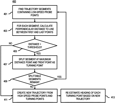
finding, by a computer-implemented map matcher, one or more segments of a probe trajectory the probe trajectory comprising a plurality of probe points and the one or more segments containing a sub-set of the plurality of probe points that are a plurality of low-speed probe points, wherein the plurality of low-speed probe points are traveling below a speed threshold, and wherein the computer-implemented map matcher uses a map matching technology to match the plurality of probe points of the probe trajectory to a road network stored in digital map data of a geographic database;
for each segment of the one or more segments, forming, by the computer-implemented map matcher, a line between a first probe point and a last probe point of the sub-set of the plurality of probe points of each segment;
calculating, by the computer-implemented map matcher, a distance from each probe point of the sub-set of the plurality of probe points of each segment to the line;
splitting, by the computer-implemented map matcher, each segment based on comparing the distance to a threshold at a turning point of each segment;
creating, by the computer-implemented map matcher, a new probe trajectory based on a plurality of high-speed probe points in the probe trajectory and the turning point of each segment, wherein the plurality of high-speed probe points are traveling above the speed threshold;
estimating, by the computer-implemented map matcher, a heading of the turning point of each segment based on the new trajectory; and
performing, by the computer-implemented map matcher, a feasibility check between two consecutive probe points of the new trajectory,
wherein the feasibility check verifies a validity of a transition between the two consecutive probe points with respect to the road network stored in the digital map data of the geographic database, and
wherein a map matching of the new trajectory, by the computer-implemented map matcher, is based on the feasibility check.
|