| CPC G06V 20/194 (2022.01) [G06V 20/13 (2022.01); G06V 20/17 (2022.01)] | 6 Claims |
|
1. A method for whole-time space-air-ground integrated hyperspectral stereoscopic remote sensing, tracing and prediction of greenhouse/pollution gas, the method comprising:
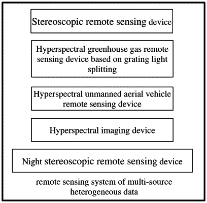
performing remote sensing of multi-source heterogeneous data: utilizing a hyperspectral stereoscopic remote sensing device, a hyperspectral imaging device, a hyperspectral unmanned aerial vehicle remote sensing device, a hyperspectral greenhouse gas remote sensing device based on grating light splitting and a night hyperspectral stereoscopic remote sensing device to perform the remote sensing of and obtain the multi-source heterogeneous greenhouse/pollution gas data, comprising: hyperspectral satellite remote sensing data, hyperspectral ground-based remote sensing data, hyperspectral horizontal remote sensing data, hyperspectral imaging remote sensing data, hyperspectral unmanned aerial vehicle remote sensing data, and environmental monitoring station site data;
performing tracing and early warning of greenhouse/pollution gas components: progressively realizing tracing of greenhouse/pollution gas components at different locations based on the multi-source heterogeneous greenhouse/pollution gas data, comprising:
step 1: realizing kilometer-level identification of the greenhouse/pollution gas components based on a hyperspectral satellite payload remote sensing technology;
step 2: in a kilometer-level greenhouse/pollution gas component high value area determined by satellite payload remote sensing, carrying out hyperspectral horizontal remote sensing to realize hundred-meter-level horizontal distribution detection and high-value orientation identification of the greenhouse/pollution gas components;
step 3: in a hundred-meter-level greenhouse/pollution gas component high value grid point determined by horizontal remote sensing, carrying out hyperspectral unmanned aerial vehicle remote sensing to realize meter-level resolution detection of the greenhouse/pollution gas components and determination of a location of an emission source; and,
step 4: at the location of the emission source determined by unmanned aerial vehicle remote sensing, carrying out hyperspectral imaging remote sensing to identify greenhouse/pollution gas components, emission fluxes and a diffusion range of the emission source, so as to realize accurate tracing of the greenhouse/pollution gas components;
performing emission early warning according to a traced result, comprising: constructing a multi-source data traversal method system and a multi-component historical excessive emission data lookup table of the greenhouse/pollution air components based on an emission specification standard and historical emission data of a target source, wherein the lookup table includes time, process flow names, pollution/greenhouse gas components and corresponding excessive emission concentrations, and determination of excessive emission is based on the emission specification standard; establishing an excessive emission early warning solution having three levels of orange, red and purple according to an excessive concentration situation, and performing early warning notification on an excessive result in the excessive data lookup table based on the excessive early warning solution; and, with the aid of a TENCENT cloud server, pushing early warning information to a relevant qualified department or a user unit through wechat, email and SMS in a real-time manner; and
performing stereo fusion and prediction of the multi-source heterogeneous data: performing data feature fusion based on the multi-source heterogeneous greenhouse/pollution gas data, comprising: firstly, using Long Short-Term Memory (LSTM) to perform long-short term time feature extraction on historical data of satellite remote sensing and ground-based hyperspectral remote sensing, and fusing emission source intensity information from ground-based imaging observation and unmanned aerial vehicle observation during a predicted time to complete missing satellite remote sensing data and ground-based hyperspectral remote sensing data; and then, pre-processing all the multi-source heterogeneous greenhouse/pollution gas data, and then using Convolutional Neural Networks (CNN) to fuse the pre-processed multi-source heterogeneous greenhouse/pollution gas data so as to obtain a fusion result;
performing prediction of the greenhouse/pollution gas components at a future moment based on the fusion result, comprising: utilizing a residual network to respectively extract and then fuse the fusion result and short-time meteorological field data features predicted by a meteorological model, and predicting stereo distribution data of air pollutants at a future moment based on the fusion result.
|