| CPC G01S 17/931 (2020.01) [G01S 7/4865 (2013.01)] | 15 Claims |
|
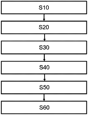
1. A computer configured for:
obtaining, by a lidar of a motor vehicle, for a plurality of measurement points located on a surface of an object, data representative of a diffuse intensity at a measurement point and of a distance between the measurement point and the lidar;
determining the direction normal to the surface tangential to each measurement point, and deducing therefrom an angle of incidence of the lidar at each measurement point;
calculating, for each measurement point, a reflectivity from the angle of incidence, the distance, and the diffuse intensity;
identifying spatially adjacent measurement points having a corresponding reflectivity within a given range of values centered on a common reflectivity value, in order to form common reflectivity zones;
defining a cost function for at least one common reflectivity zone, the cost function comprising a plurality of terms, each term being relative to a measurement point and comprising a first diffuse intensity obtained using the data representative of the diffuse intensity and a second diffuse intensity determined as a function of the common reflectivity value, the angle of incidence, and the distance of the measurement point in question;
minimizing the cost function, using an iterative non-linear optimization algorithm, in order to update at least one of the angle of incidence, the distance, and the reflectivity at the measurement point, for each of the measurement points belonging to a common reflectivity zone;
identifying objects based on the updated at least one of the angle of incidence, the distance, and the reflectivity at the measurement point, for each of the measurement points belonging to the common reflectivity zone; and
using the identified objects in at least one of emergency braking or line change detection of an Advanced Driver Assistance System (“ADAS”) of the motor vehicle comprising the lidar.
|