| CPC G01K 7/427 (2013.01) | 8 Claims |
|
1. An anthropogenic heat flux estimation method based on flux observation data, comprising:
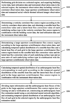
performing grid division on a selected region, and acquiring building vector data, land utilization data and instrument observation data in the selected region, wherein the instrument observation data comprises vorticity correlator observation data, large-aperture scintillometer observation data and unmanned aerial vehicle thermal infrared imager observation data;
determining a vorticity correlator flux source region according to the vorticity correlator observation data, and obtaining a sensible heat flux correction value and a latent heat flux correction value of each underlying surface type in the vorticity correlator flux source region in combination with the building vector data, the land utilization data and the instrument observation data, comprising: inputting the vorticity correlator observation data into a preset footprint model to obtain the vorticity correlator flux source region corresponding to the selected region; calculating a sensible heat flux calculation value of each underlying surface type corresponding to the vorticity correlator flux source region according to the building vector data and the instrument observation data; calculating a latent heat flux calculation value of each underlying surface type corresponding to the vorticity correlator flux source region according to the building vector data and the instrument observation data; and according to the land utilization data and the vorticity correlator observation data, performing data correction on the sensible heat flux calculation value and the latent heat flux calculation value of each underlying surface type corresponding to the vorticity correlator flux source region, so as to obtain the sensible heat flux correction value and the latent heat flux correction value of each underlying surface type;
determining a large-aperture scintillometer flux source region according to the large-aperture scintillometer observation data, and calculating temporal-spatial distribution of a sensible heat flux and a latent heat flux of each grid in the large-aperture scintillometer flux source region based on the sensible heat flux correction value and the latent heat flux correction value of each underlying surface type and an area ratio of each underlying surface type in combination with the large-aperture scintillometer observation data;
calculating temporal-spatial distribution of an anthropogenic heat flux corresponding to each grid according to the temporal-spatial distribution of the sensible heat flux and the latent heat flux of each grid in the large-aperture scintillometer flux source region in combination with the instrument observation data; and
dividing input information and anthropogenic heat fluxes of grids in the large-aperture scintillometer flux source region into a training set and a verification set according to a certain proportion, constructing an anthropogenic heat flux estimation model using a convolutional neural network algorithm, and estimating the temporal-spatial distribution of the anthropogenic heat flux of each grid in the selected region by the anthropogenic heat flux estimation model.
|