| CPC G01C 21/1656 (2020.08) [G01C 21/1652 (2020.08); G01S 17/86 (2020.01); G01S 17/89 (2013.01); G01S 17/931 (2020.01); G06F 18/24 (2023.01); G06F 18/2415 (2023.01); G06V 10/757 (2022.01); G06V 10/764 (2022.01); G06V 20/56 (2022.01); G06T 17/05 (2013.01)] | 17 Claims |
|
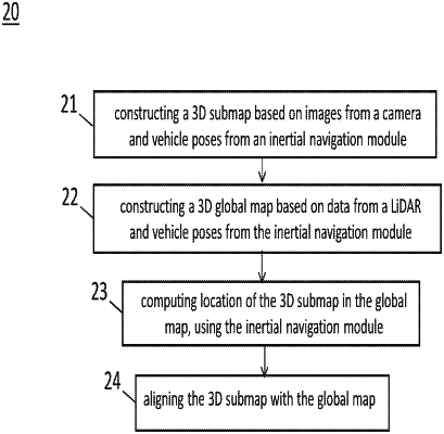
1. A method of localization comprising
processing of images from a camera and processing a data from a light detection and ranging (LiDAR), the processing comprising:
constructing a 3D submap using images from the camera and vehicle pose information;
constructing a 3D global map generated from the data from the LiDAR and vehicle pose information;
computing the location of the 3D submap in the global map, wherein the location of the 3D submap includes center position of the 3D submap; and
aligning the 3D submap with the global map.
|