| CPC B60W 60/001 (2020.02) [B60W 10/18 (2013.01); B60W 10/20 (2013.01); G01C 21/3819 (2020.08); G01C 21/3841 (2020.08); B60W 2420/403 (2013.01); B60W 2552/53 (2020.02); B60W 2556/10 (2020.02); B60W 2556/40 (2020.02); B60W 2710/18 (2013.01); B60W 2710/20 (2013.01); B60W 2720/106 (2013.01)] | 20 Claims |

|
1. A system, comprising:
a processor; and
a memory storing machine-readable instructions that, when executed by the processor, cause the processor to:
receive image data of a portion of a roadway;
receive historical vehicle trajectory data for the portion of the roadway;
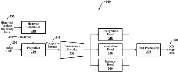
generate, from the historical vehicle trajectory data, a heatmap indicating, for a given pixel in the heatmap, an extent to which the given pixel coincides spatially with one or more vehicle trajectories in the historical vehicle trajectory data; and
project the heatmap onto the image data to generate a composite image and use the composite image in training a neural network to detect roadway lane boundaries, wherein the projected heatmap acts as supervisory data;
wherein the trained neural network is deployed in a vehicle to perform one of generating map data used to control, at least in part, operation of another vehicle to which the map data is downloaded and controlling operation of the vehicle based, at least in part, on roadway lane boundaries detected by the trained neural network.
|