| CPC G06T 7/0002 (2013.01) [G06F 18/214 (2023.01); G06N 20/00 (2019.01); G06Q 50/16 (2013.01); G06V 20/176 (2022.01); G06V 20/188 (2022.01); G06Q 30/0278 (2013.01); G06Q 40/08 (2013.01); G06Q 50/26 (2013.01); G06T 2207/20081 (2013.01); G06T 2207/30188 (2013.01)] | 19 Claims |

|
1. A method comprising:
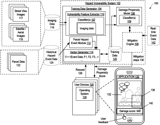
receiving a request for a damage propensity score for a parcel, the request specifying responsive to an occurrence of a real-time hazard event;
receiving hazard event data for the real-time hazard event, the hazard event data comprising a current set of hazard conditions of the real-time hazard event and including a degree of exposure of the parcel to the real-time hazard event;
receiving imaging data for the parcel, wherein the imaging data comprises street-view imaging data of the parcel;
extracting, by a machine-learned model comprising a plurality of classifiers and using object recognition, characteristics of a plurality of vulnerability features for the parcel from the imaging data, the plurality of vulnerability features comprising structures and vegetation;
determining, by the machine-learned model and from the characteristics of the plurality of vulnerability features and in response to the hazard event data for the real-time hazard event, the damage propensity score for the parcel, the damage propensity score indicating a measure of risk to the parcel including the characteristics of the plurality of vulnerability features of damage due to the real-time hazard event; and
providing a representation of the damage propensity score for the parcel responsive to the real-time hazard event for display.
|