| CPC G06T 3/4007 (2013.01) [A01D 41/127 (2013.01); G06N 3/047 (2023.01); G06N 3/08 (2013.01); G06Q 10/04 (2013.01); G06Q 50/02 (2013.01); G06T 5/50 (2013.01); G06T 7/0016 (2013.01); G06T 7/143 (2017.01); G06V 10/82 (2022.01); G06V 20/13 (2022.01); G06V 20/188 (2022.01); G06T 2207/10016 (2013.01); G06T 2207/10032 (2013.01); G06T 2207/10048 (2013.01); G06T 2207/20081 (2013.01); G06T 2207/20084 (2013.01); G06T 2207/20221 (2013.01); G06T 2207/30181 (2013.01); G06T 2207/30188 (2013.01); G06V 20/194 (2022.01)] | 20 Claims |

|
1. A method implemented using one or more processors, comprising:
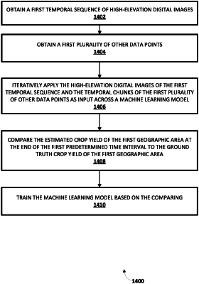
obtaining a temporal sequence of high-elevation digital images, wherein the temporal sequence of high elevation digital images capture a geographic area under consideration through at least part of a crop cycle of a selected type of crop growing in the geographic area; and
generating a ground truth crop yield prediction of the geographic area at the end of the crop cycle of the selected type of crop growing in the geographic area by applying the high-elevation digital images of the temporal sequence and ground truth operational data associated with the geographic area under consideration as input across a machine learning model, wherein the ground truth operational data includes data about one or more of
application of pesticide in the geographic area;
application of fertilizer in the geographic area; or
crop rotation implemented in the geographic area.
|