| CPC G06T 17/05 (2013.01) [G06F 17/16 (2013.01); G06T 19/20 (2013.01); G06T 2210/32 (2013.01); G06T 2219/2016 (2013.01)] | 19 Claims |
|
1. A method for correcting space coordinates of a three-dimensional model, comprising:
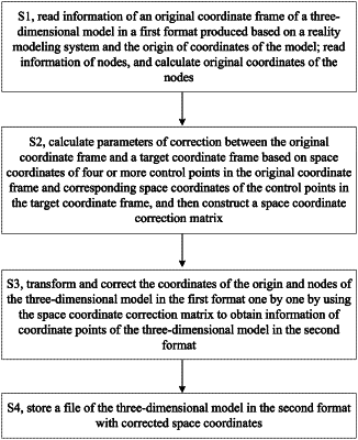
step S1, reading information of an original coordinate frame of a three-dimensional model in a first format produced based on a reality modeling system and the origin of coordinates of the model; reading information of nodes from three-dimensional model data in the first format, and calculating original coordinates of the nodes; wherein the three-dimensional model in the first format is a three-dimensional model in OpenSceneGraph Binary Scene Data (OSGB) format produced based on ContextCapture reality modeling system;
step S2, calculating parameters of correction between the original coordinate frame and a target coordinate frame based on space coordinates of four or more control points in the original coordinate frame in the first format and corresponding space coordinates of the four or more control points in the target coordinate frame in a second format, and constructing a space coordinate correction matrix, wherein the control points are noncoplanar arbitrary points in regions of the three-dimensional model;
step S3, transforming and correcting the coordinates of the origin and nodes of the three-dimensional model in the first format one by one by using the space coordinate correction matrix to obtain information of coordinate points of the three-dimensional model in the second format; and
step S4, storing a file of the three-dimensional model in the second format with corrected space coordinates.
|