| CPC G06T 17/05 (2013.01) [A63F 13/52 (2014.09); A63F 13/80 (2014.09); G06T 19/006 (2013.01); A63F 2300/64 (2013.01); A63F 2300/66 (2013.01)] | 20 Claims |

|
1. A method for generating game terrain data of a video game application within a graphical user interface, wherein the method includes:
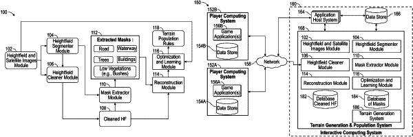
receiving first height field data of a first real world geographical location and a first top view image of the first real world geographical location, wherein the first top view image is a satellite image of the first real world geographical location comprising real world terrain, and wherein the first height field data comprises elevation data of the real world terrain within the first real world geographical location;
in response to receiving the first height field data and the first top view image, generating a segmented image by:
identifying categories of terrain type based on the first top view image and the first height field data; and
applying masks corresponding to the categories of the terrain type to the first height field data to generate the segmented image;
accessing terrain population rules for each of the identified categories of terrain type;
in response to generating the segmented image, generating three-dimensional virtual objects that correspond to the identified categories of terrain type based at least in part on the terrain population rules;
placing the three-dimensional virtual objects in a three-dimensional virtual space based on the terrain population rules;
generating a second top view virtual image of the three-dimensional virtual space;
determining an amount of variance between the three-dimensional virtual space and the first real world geographical location by comparing the second top view virtual image of the three-dimensional virtual space and the first top view image of the first real world geographical location; and
in response to the amount of variance satisfying a predetermined threshold, applying the terrain population rules to generate terrain data for the video game application.
|