| CPC G01V 3/30 (2013.01) [E21B 49/00 (2013.01); E21B 2200/20 (2020.05)] | 20 Claims |
|
1. A system for evaluating a subterranean earth formation having a wellbore intersecting the subterranean earth formation, comprising:
a logging tool operable to measure formation data and locatable in the wellbore, wherein the logging tool comprises:
a transmitter antenna; and
a receiver antenna; and
a processor and a non-transitory memory device in data communication with the logging tool, wherein the non-transitory memory device comprises instructions that, when executed by the processor, cause the processor to:
control a current and a voltage sourced to the transmitter antenna, causing the transmitter antenna to transmit a first electromagnetic signal into the subterranean earth formation at a plurality of depths along the wellbore;
receive, via the receiver antenna, a plurality of second electromagnetic signals at the plurality of depths along the wellbore, wherein each of the plurality of second electromagnetic signals is emitted by the subterranean earth formation in response to the first electromagnetic signal as the logging tool traverses the plurality of depths along the wellbore;
calculate a plurality of resistivity values for the plurality of second electromagnetic signals;
calculate a plurality of solutions to an inversion algorithm of the subterranean earth formation, wherein each of the plurality of solutions comprises a solution resistivity measurement as a function of the plurality of depths along the wellbore;
filter the plurality of solutions according to a filter threshold value into a plurality of convergent solutions;
pixilate each of the convergent solutions of the plurality of convergent solutions into a pixilated convergent solution of a plurality of pixilated convergent solutions;
calculate one or more ensemble statistics for the plurality of pixilated convergent solutions;
calculate a difference in resistivity value between successive pixels in each of the pixilated convergent solutions of the plurality of pixilated convergent solutions along the plurality of depths along the wellbore;
identify one or more presumptive layer boundaries based on the differences in resistivity values between the successive pixels;
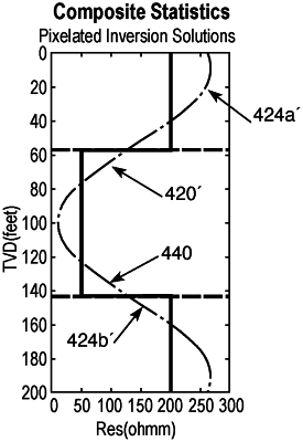
calculate one or more composite resistivity statistics of the plurality of pixilated convergent solutions based at least in part on the one or more presumptive layer boundaries and the one or more ensemble statistics; and
generate a formation model based on the one or more composite resistivity statistics.
|