| CPC G06T 17/05 (2013.01) [G01S 17/89 (2013.01); H04L 67/01 (2022.05); G06T 2200/08 (2013.01); G06T 2210/56 (2013.01); G06T 2215/12 (2013.01); G06T 2215/16 (2013.01)] | 20 Claims |
|
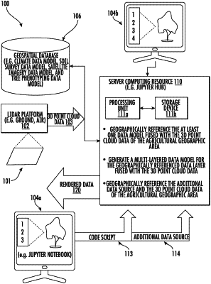
1. An agricultural modeling system for processing data for an agricultural geographic area, the agricultural modeling system comprising:
a mobile ranging platform configured to generate three-dimensional (3D) point cloud data of the agricultural geographic area;
a plurality of client devices, the plurality of client devices being arranged in subsets;
a geospatial database configured to store at least one data layer for the agricultural geographic area and having a resolution less than or equal to the 3D point cloud data of the agricultural geographic area; and
a server computing resource in communication with said mobile ranging platform, said plurality of client devices, and said geospatial database, said server computing resource configured to
geographically reference the at least one data layer fused with the 3D point cloud data of the agricultural geographic area, and
generate a multi-layered data model for the geographically referenced at least one data layer fused with the 3D point cloud data of the agricultural geographic area;
a given client device from a given subset of client devices and configured to
upload an additional data source to said server computing resource, said server computing resource configured to geographically reference and fuse the additional data source and the 3D point cloud data of the agricultural geographic area,
selectively render the multi-layered data model including the additional data source, the multi-layered data model being unique to the given client device, and
share the multi-layered data model including the additional data source with the given subset of client devices while isolating the multi-layered data model including the additional data source from other subsets of client devices.
|