| CPC G06Q 50/02 (2013.01) [G06F 16/29 (2019.01); G06Q 30/018 (2013.01); G06Q 2220/00 (2013.01)] | 18 Claims |

|
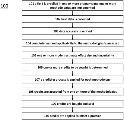
1. A computer-implemented method comprising:
receiving, at a computing node, field data comprising geospatial boundaries of one or more field;
accessing, by the computing node, one or more methodology;
for each of the one or more fields, accessing, by the computing node, one or more farming practice, wherein each farming practice comprises a location and time;
determining, by the computing node, one or more farming practice that is missing or non-compliant;
accessing, by the computing node, remote sensing data and, optionally, historical farming practice data;
applying, by the computing node, a trained machine learning model to the remote sensing data and, optionally, historical farming practice data, to generate an estimate of the one or more missing or non-compliant farming practice;
updating the one or more farming practice with the estimate of the one or more missing or non-compliant farming practice;
generating, by the computing node, for each of the one or more fields, for each crop production period, an ecosystem attribute by applying one or more ecosystem attribute quantification methods to each spatially and temporally unique set of one or more updated farming practices; and
optimizing, by the computing node, selection of one or more program for each field based on a set of selected programs being compatible within the field and production period,
wherein optimization is based on one or more of: maximizing a beneficial change in an ecosystem attribute, maximizing permanence of an ecosystem attribute, reducing a permanence risk of an ecosystem attribute, maximizing a benefit to plant health, maximizing a benefit to soil health, reducing uncertainty in a quantification of an ecosystem attribute, and maximizing the overall ecosystem impact for the field.
|