| CPC A01C 21/005 (2013.01) [A01B 69/008 (2013.01); A01B 79/02 (2013.01); G05D 1/0274 (2013.01); G06Q 50/02 (2013.01); A01B 49/06 (2013.01); G05D 2201/0201 (2013.01)] | 20 Claims |

|
1. A system comprising:
one or more processors; and
a memory storing instructions which, when executed by the one or more processors, cause performance of:
creating a plurality of data files by performing, for each data file of the plurality of data files:
identifying a start condition;
in response to identifying the start condition, generating a new data file;
recording data of an apparatus moving through an agricultural field in the new data file, the data comprising locations of the apparatus during said recording;
identifying a stop condition; and
in response to identifying the stop condition, storing the new data file, the new data file being a data file in the plurality of data files;
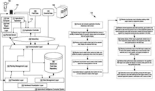
displaying a field map corresponding to the agricultural field through a graphical user interface;
receiving input through the graphical user interface selecting multiple locations on the field map;
for each selected location of the multiple locations, identifying a corresponding data file of the plurality of data files;
generating a geographic region comprising locations in the identified corresponding data files, the geographic region being bounded by edges of the locations in the identified corresponding data files;
displaying the geographic region through the graphical user interface; and
updating the graphical user interface to include a data panel corresponding to the geographic region.
|