US 11,874,119 B2
Traffic boundary mapping
Jonathan Albert Cox, Albuquerque, NM (US); Veeresh Taranalli, San Francisco, CA (US); David Jonathan Julian, San Diego, CA (US); Badugu Naveen Chakravarthy, Bengaluru (IN); Michael Campos, La Jolla, CA (US); Adam David Kahn, San Diego, CA (US); Venkata Ramanan Venkatachalam Jayaraman, San Diego, CA (US); and Arvind Yedla, La Jolla, CA (US)
Assigned to NETRADYNE, INC., San Diego, CA (US)
Filed by NETRADYNE, INC., San Diego, CA (US)
Filed on Jan. 8, 2021, as Appl. No. 17/145,230.
Application 17/145,230 is a continuation of application No. 16/608,516, granted, now 10,891,497, previously published as PCT/US2019/023766, filed on Mar. 22, 2019.
Claims priority of provisional application 62/647,526, filed on Mar. 23, 2018.
Prior Publication US 2021/0142077 A1, May 13, 2021
Int. Cl. G01C 21/30 (2006.01); G06V 20/56 (2022.01); G06F 18/214 (2023.01); G06V 10/764 (2022.01); G06V 10/774 (2022.01); G06V 10/80 (2022.01); G06V 10/82 (2022.01); G06V 20/10 (2022.01)
CPC G01C 21/30 (2013.01) [G06F 18/214 (2023.01); G06V 10/764 (2022.01); G06V 10/774 (2022.01); G06V 10/80 (2022.01); G06V 10/82 (2022.01); G06V 20/10 (2022.01); G06V 20/588 (2022.01)] 20 Claims
OG exemplary drawing
 
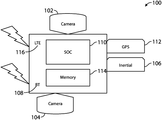
1. A method, comprising:
receiving visual data from a camera on a vehicle;
detecting a traffic boundary within the visual data;
selecting a first one or more cells of an occupancy grid based on a bird's eye view projection of the detected traffic boundary, wherein each cell of the occupancy grid corresponds to a position on a road relative to the vehicle;
incrementing a value of the first one or more cells;
receiving a portion of a traffic boundary map;
computing a cross-correlation between the occupancy grid and the portion of the traffic boundary map to produce at least one consistency value; and
localizing the vehicle within the traffic boundary map based on the at least one consistency value.