| CPC H04W 72/566 (2023.01) [H04L 45/308 (2013.01); H04L 67/306 (2013.01); H04W 4/90 (2018.02); H04W 36/305 (2018.08); H04W 40/12 (2013.01); H04W 40/36 (2013.01)] | 20 Claims |
|
1. A method of monitoring a wireless communication network and managing priority uplift for mobile communication devices of public stewardship workers, comprising:
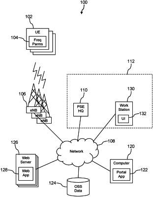
receiving operations data by a public stewardship entity network portal application executing on a computer system, where the operations data is about a plurality of cell sites in a wireless communication network;
receiving an input by the public stewardship entity network portal application from a user interface of the public stewardship entity network portal application selecting a geographic location and selecting a geographic scale;
presenting a wireless communication network status map by the public stewardship entity network portal application based on the operations data, where the wireless communication network status map indicates an operating status of cell sites among the plurality of cell sites in the wireless communication network that are located in an area defined by the selected geographic location and the selected geographic scale;
receiving an input by the public stewardship entity network portal application from the user interface of the public stewardship entity network portal application selecting an event type mapping overlay;
retrieving event information by the public stewardship entity network portal application from a web server associated with the selected event type mapping overlay;
presenting event information by the public stewardship entity network portal application overlaid on the wireless communication network status map according to the input geographic scale and input geographic location;
receiving an input by the public stewardship entity network portal application from the user interface of the public stewardship entity network portal application identifying a location of a public stewardship event;
determining by the public stewardship entity network portal application based on the operations data that wireless communication service of at least one cell site proximate to the location of the public stewardship event is impaired; and
based on the determination that wireless communication service of at least one cell site proximate to the location of the public stewardship event is impaired, uplifting by the public stewardship entity network portal application a priority of mobile communication devices of public stewardship workers dispatched to respond to the public stewardship event such that the mobile communication devices of the public stewardship workers dispatched to respond to the public stewardship event are provided a wireless communication link while at the location of the public stewardship event.
|