| CPC G06T 15/00 (2013.01) [G06N 3/08 (2013.01); G06T 5/006 (2013.01); G06T 7/136 (2017.01); G06T 7/149 (2017.01); G06T 7/536 (2017.01); G06T 7/73 (2017.01); G06V 20/00 (2022.01); G06T 2207/20081 (2013.01); G06T 2207/30204 (2013.01); G06T 2207/30224 (2013.01); H04W 4/80 (2018.02)] | 20 Claims |
|
1. A system for determining an absolute position of an object of interest in an area of interest, comprising:
a server having a processor and memory;
a plurality of cameras operably coupled to the server, each of the plurality of cameras disposed about an area of interest and acquiring one or more images of an object of interest and the area of interest within a field of view of the camera;
the processor of the server configured to determine an absolute position of the object of interest in the area of interest by:
receiving the one or more images acquired by at least one of the plurality of cameras;
identifying an approximate location of the object of interest in the area of interest in at least one image of the plurality of images based on a report signal received from an object detector;
detecting the object of interest within the approximate location of the object of interest by image analysis techniques;
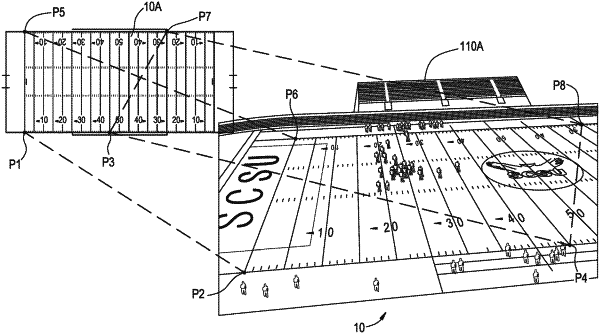
determining a relative position of the detected object of interest in a first region of interest proximate to the detected object of interest, the relative position of the detected object of interest defined by pixel coordinates;
detecting stationary markers within a second region of interest proximate to the detected object of interest, the detected stationary markers proximate to the relative position of the object of interest and defined in pixel coordinates;
generating a field map of the area of interest including the second region of interest and the detected stationary markers;
determining the relative position of the object of interest in pixel coordinates in relation to at least one detected stationary marker of the field map;
converting the relative position of the object of interest from the pixel coordinates to x-y coordinates to yield an absolute position of the object of interest in the area of interest; and
providing the absolute position of the object of interest in the area of interest.
|