| CPC G06T 17/20 (2013.01) [B60W 30/143 (2013.01); B60W 40/06 (2013.01); B60W 50/06 (2013.01); B60W 60/0015 (2020.02); G06F 18/214 (2023.01); G06F 18/24 (2023.01); G06N 3/08 (2013.01); G06T 7/11 (2017.01); G06T 7/40 (2013.01); B60W 2420/403 (2013.01); B60W 2420/408 (2024.01); G06T 2200/08 (2013.01); G06T 2207/20081 (2013.01); G06T 2207/20084 (2013.01)] | 21 Claims |
|
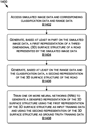
1. A method comprising:
accessing simulated data comprising simulated image data and at least one of classification data corresponding to the simulated image data or range data corresponding to the simulated image data;
generating, based at least on the simulated image data, a first three-dimensional (3D) representation of a surface structure of a simulated road represented by the simulated image data;
generating, based at least on the at least one of the classification data corresponding to the simulated image data or the range data corresponding to the simulated image data, a second 3D representation of the surface structure of the simulated road; and
training one or more neural networks (NNs) to generate a densified 3D representation of the surface structure using the first 3D representation of the surface structure as input training data and using the second 3D representation of the surface structure as ground truth training data.
|