| CPC G01S 17/894 (2020.01) [G06T 7/521 (2017.01); G06T 7/73 (2017.01); G06T 2207/10028 (2013.01); G06T 2207/30252 (2013.01)] | 20 Claims |

|
1. A three-dimensional point cloud data processing method for processing, using a processor, three-dimensional point cloud data, the three-dimensional point cloud data processing method comprising:
obtaining (i) a two-dimensional image obtained using a camera and (ii) a first three-dimensional point cloud obtained using a distance sensor;
detecting, from the two-dimensional image obtained in the obtaining, a feature value of the two-dimensional image, the feature value being associated with a two-dimensional coordinate value in a two-dimensional image and one of a plurality of first three-dimensional points included in the first three-dimensional point cloud;
generating first three-dimensional point cloud data that includes a plurality of first three-dimensional point data items associated one to one with the plurality of first three-dimensional points included in the first three-dimensional point cloud, the plurality of first three-dimensional point data items each being a combination of (i) a three-dimensional coordinate value of an associated first three-dimensional point out of the plurality of first three-dimensional points, (ii) the feature value of the associated first three-dimensional point, and (iii) a confidence value of the three-dimensional coordinate value of the associated first three-dimensional point, each of the plurality of first three-dimensional point data items being associated with each of the plurality of first three-dimensional points included in the first three-dimensional point cloud; and
selecting, based on the confidence value, a first three-dimensional point from among the plurality of first three-dimensional point cloud to output a first three-dimensional point data item associated to the selected first three-dimensional point,
wherein the confidence value indicates certainty of a coordinate position of the first three-dimensional point, and
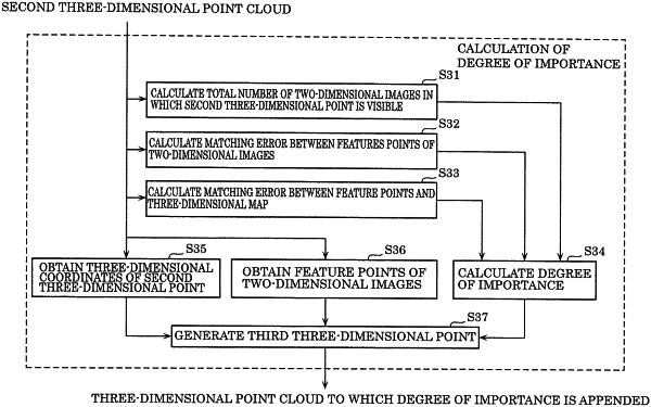
wherein the confidence value is calculated based on a total number of two-dimensional images in which the associated three-dimensional point is observed, the confidence value increasing as the total number of two-dimensional images in which the associated three-dimensional point is observed increases.
|