| CPC G01N 33/246 (2013.01) [G01N 21/17 (2013.01); G01N 2021/1765 (2013.01); G01N 2021/178 (2013.01); G01N 2021/1797 (2013.01); G01N 2201/0407 (2013.01)] | 6 Claims |

|
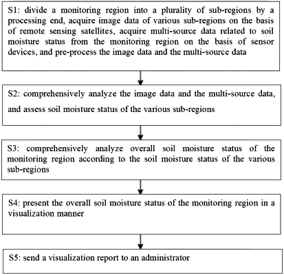
1. An intelligent monitoring method for soil moisture status based on remote sensing technology, comprising the following steps:
S1: dividing a monitoring region into a plurality of sub-regions by a processing end, acquiring image data of various sub-regions on the basis of remote sensing satellites, acquiring multi-source data related to soil moisture status of the monitoring region on the basis of sensor devices, and pre-processing the image data and the multi-source data,
S2: comprehensively analyzing the image data and the multi-source data, and assessing soil moisture status of the various sub-regions,
S3: comprehensively analyzing overall soil moisture status of the monitoring region according to the soil moisture status of the various sub-regions,
S4: presenting the overall soil moisture status of the monitoring region in a visualization manner, and
S5: sending a visualization report to an administrator, wherein
in step S2, the image data and the multi-source data are comprehensively analyzed, the image data comprising a color segmentation index, and the multi-source data comprising a humidity coefficient and a moisture content float coefficient; and
in step 2, the assessing soil moisture status of the various sub-regions comprises the following steps:
S2. 1: calculating a moisture status coefficient sqx by combining the color segmentation index, the humidity coefficient, and the moisture content float coefficient through the following expression:
 where sdx represents the humidity coefficient, ysf represents the color segmentation index, hsf represents the moisture content float coefficient, and α, β, and γ represent proportionality coefficients of the humidity coefficient, the color segmentation index, and the moisture content float coefficient, respectively, α, β, and γ being greater than 0, and
S2. 2: assessing soil moisture status in a sub-region to be good if a value of the moisture status coefficient sqx is greater than or equal to a moisture status threshold, and assessing soil moisture status in a sub-region to be poor if a value of the moisture status coefficient sqx is less than the moisture status threshold; and
in step S3: the comprehensively analyzing overall soil moisture status of the monitoring region according to the soil moisture status of the various sub-regions comprises the following steps:
S3. 1: acquiring the number of sub-regions, and acquiring values of the moisture status coefficient sqx of the various sub-regions,
S3. 2: calculating an average moisture status coefficient value of all the sub-regions,
S3. 3: calculating a moisture status coefficient dispersion degree of the monitoring region on the basis of the values of the moisture status coefficient sqx and the average moisture status coefficient value of the sub-regions, and
S3. 4: analyzing soil moisture status of the monitoring region and a variation trend of the soil moisture status according to the moisture status coefficient dispersion degree of the monitoring region, wherein
in step S3.4, an expression for calculating the moisture status coefficient dispersion degree jqs of the monitoring region is as follows:
 where b={1, 2, 3, . . . , c}, c representing the number of sub-regions, and being a positive integer, Rb represents a value of the moisture status coefficient sqx in a bth sub-region, and R represents the average moisture status coefficient value,
if the average moisture status coefficient value is greater than or equal to the moisture status threshold and the moisture status coefficient dispersion degree is less than or equal to a dispersion threshold, the overall soil moisture status of the monitoring region being analyzed to be good, and trending towards good in the future,
if the average moisture status coefficient value is greater than or equal to the moisture status threshold and the moisture status coefficient dispersion degree is greater than the dispersion threshold, the overall soil moisture status of the monitoring region being analyzed to be moderate, and unstable factors existing in the future development trend of the soil moisture status,
if the average moisture status coefficient value is less than the moisture status threshold and the moisture status coefficient dispersion degree is greater than the dispersion threshold, the overall soil moisture status of the monitoring region being analyzed to be poor, and unstable factors existing in the future development trend of the soil moisture status, and
if the average moisture status coefficient value is less than the moisture status threshold and the moisture status coefficient dispersion degree is less than or equal to the dispersion threshold, the overall soil moisture status of the monitoring region being analyzed to be very poor, and trending towards bad in the future.
|