| CPC G06T 11/203 (2013.01) [G06F 3/14 (2013.01); G06T 7/50 (2017.01); G06T 7/60 (2013.01); G06T 7/70 (2017.01); G06T 11/60 (2013.01); G06V 30/1448 (2022.01); G06V 30/242 (2022.01); G06V 30/41 (2022.01); G06T 2200/28 (2013.01); G06T 2207/30176 (2013.01); G06T 2210/12 (2013.01); G06T 2210/32 (2013.01)] | 15 Claims |
|
1. A system, comprising:
at least one computer readable medium; and
at least one processor communicatively coupled to the at least one computer readable medium, the at least one processor configured to:
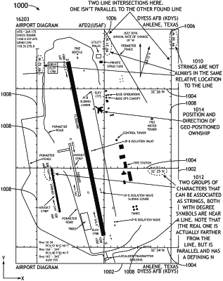
obtain a graphical image file, the graphical image file including an image of an airport terminal chart, wherein the image includes at least one portion including textual characters;
identify two lines of latitude in the image;
identify a latitudinal set of characters, in the image, associated with a latitude for each of the two lines of latitude;
based at least on the latitudinal set of characters, determine a latitude for each of the two lines of latitude;
based at least on the latitude for each of the two lines of latitude and a first image distance between the two lines of latitude, determine a first ratio of latitudinal degrees between the two lines of latitude to the first image distance;
identify two lines of longitude in the image;
identify a longitudinal set of characters, in the image, associated with a longitude for each of the two lines of longitude;
based at least on the longitudinal set of characters, determine a longitude for each of the two lines of longitude;
based at least on the longitude for each of the two lines of longitude and a second image distance between the two lines of longitude, determine a second ratio of longitudinal degrees between the two lines of longitude to the second image distance;
convert the graphical image file to at least one file including hardware directives that when executed cause a recreation of the image of the graphical image file to be drawn; and
output information associated with the first ratio, the second ratio, the determined latitude for each of the two lines of latitude, and the determined longitude for each of the two lines of longitude.
|