| CPC G06Q 40/03 (2023.01) | 16 Claims |
|
1. A system for geographical mapping and linking of disparate data structures for interaction, the system comprising:
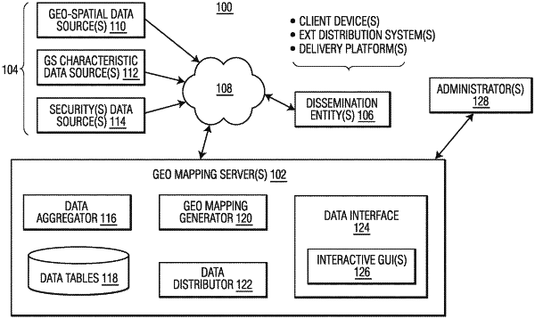
at least one server in communication with one or more data source systems, the one or more data source systems configured to generate goo-spatial data, security data and additional data, the at least one server configured to:
obtain and store, in at least one storage structure, data from among the one or more data source systems, the data comprising the geo-spatial data, the security data, and the additional data;
create, in the at least one storage structure, filtered data tables including at least one first data table, at least one second data table, and at least one third data table;
create one or more cross-references between one or more location indicators and one or more geo-spatial areas based on at least one statistical algorithm, in accordance with the geo-spatial data, wherein the at least one statistical algorithm is configured to query the geo-spatial data and map the one or more location indicators to the one or more geo-spatial areas based on a maximum area of intersection between the one or more location indicators in accordance with at least one predetermined criteria;
store the one or more cross-references in the at least one first data table;
generate, for each of the one or more geo-spatial areas, at least one credit risk indicator based on the additional data, to form credit risk indicator data;
store the credit risk indicator data in the at least one second data table;
identify at least one security of the security data, the identified at least one security associated with at least one among the one or more location indicators;
create one or more links among the identified at least one security, the one or more geo-spatial areas and the at least one credit risk indicator among the credit risk indicator data, based on the one or more cross-references in the at least one first data table, to form instrument-level data for the identified at least one security including the at least one credit risk indicator;
store the instrument-level data for the identified at least one security in the at least one third data table;
at least one of: update one or more existing data entries stored among the filtered data tables and add one or more new data entries among the filtered data tables in response to any changes in the data obtained from the one or more data source systems; and
generate an interactive graphical user interface (GUI) via at least one interactive webpage, the interactive GUI comprising one or more user tools, the one or more user tools configured to query the filtered data tables including any updated data entries and any added data entries.
|