| CPC G06Q 30/0202 (2013.01) [G06Q 10/0637 (2013.01)] | 20 Claims |
|
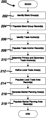
1. A method for dynamically generating an at least one market planning area for an at least one business location, the method comprising the steps of:
implementing a central computing system configured for receiving and processing select data related to each of the at least one market planning area and business location, the computing system in selective communication with an at least one business database;
the computing system accessing an at least one census database containing select data associated with a plurality of contiguous block groups that form a larger geographic region within which the at least one business location is geographically positioned;
the computing system identifying a plurality of said block groups stored within the at least one census database that are geographically proximal to the at least one business location;
for each of the identified block groups:
the computing system establishing a block group (“BG”) record using data obtained from the at least one census database, said BG record containing at least one of a unique BG identifier, a census tract corresponding to said block group, BG coordinates containing geographic coordinates of said block group, a BG shapefile containing a polygon representing geographic boundaries of said block group based on the BG coordinates, a population centroid containing geographic coordinates of the population centroid for said block group, a BG population count containing a current estimated population of residents within said block group, and a trade anchor table containing a trade anchor record for each of an at least one trade anchor determined by the computing system to be geographically located within said block group;
the computing system accessing at least one business database containing select data associated with a plurality of convenience-based retailers;
the computing system comparing the BG coordinates of said block group against geographic coordinates of said convenience-based retailers stored within the at least one business database to determine whether one or more of said convenience-based retailers are geographically positioned within said block group;
the computing system identifying at least one trade anchor geographically positioned within said block group;
for each of the at least one identified trade anchor, the computing system establishing a trade anchor record using data obtained from the at least one business database, said trade anchor record containing at least one of a unique anchor identifier, the BG identifier of the corresponding block group for said trade anchor, anchor coordinates containing geographic coordinates of said trade anchor, an anchor type containing a classification type for said trade anchor, and a retailer table containing select details associated with each of the at least one convenience-based retailer determined by the computing system to be geographically located within said trade anchor;
the computing system setting the anchor type for a one of the identified trade anchors for said block group to be a primary trade anchor, and setting the anchor type for any other identified trade anchors for said block group to be a secondary trade anchor;
the computing system defining a plurality of local trade areas based on the identified block groups;
for each of the local trade areas, the computing system establishing a local trade area (“LTA”) record containing at least one of a unique LTA identifier, LTA coordinates containing geographic coordinates of said local trade area, an LTA shapefile containing a polygon representing geographic boundaries of said local trade area based on the combined BG shapefiles of each block group geographically located within said local trade area, an LTA population count containing a current estimated population of residents within said local trade area, and a block group table containing the block group record for each block group geographically located within said local trade area;
the computing system defining an at least one market planning area based on the local trade areas; and
for each of the at least one market planning area, the computing system establishing a market planning area (“MPA”) record containing at least one of a unique MPA identifier, MPA coordinates containing geographic coordinates of said market planning area, an MPA shapefile containing a polygon representing geographic boundaries of said market planning area based on the combined LTA shapefiles of each local trade area geographically located within said market planning area, an MPA population count containing a current estimated population of residents within said market planning area, and an LTA table containing the LTA record for each local trade area geographically located within said market planning area.
|