| CPC G01V 1/345 (2013.01) [G01V 1/301 (2013.01); G01V 1/306 (2013.01); G06T 11/003 (2013.01)] | 18 Claims |

|
1. A method comprising:
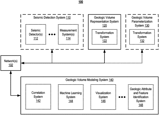
receiving, by one or more computing devices, a discrete three-dimensional representation of a geologic volume comprising a set of three-dimensional orientations in the geologic volume, wherein:
each three-dimensional orientation in the set of three-dimensional orientations is represented as a set of direction-angles measured relative to a set of coordinate axes,
each direction-angle in the set of direction-angles is a scalar value, and
each direction-angle in the set of direction-angles is assigned to a respective channel in a set of channels;
receiving, by the one or more computing devices, a set of other measurements of properties of the geologic volume;
correlating, by the one or more computing devices, the set of three-dimensional orientations with the set of other measurements to generate a geologic correlation data structure;
identifying, by the one or more computing devices, a geologic feature or a geologic attribute associated with the geologic volume based on the geologic correlation data structure;
training a direction-angle classifier machine learning model comprising a process of:
generating, for each direction-angle in the set of direction-angles, a respective probability value that the respective direction-angle corresponds to a property of a hot sedimentary aquifer (HSA),
modifying, based on the respective probability value generated for the respective direction-angle, each direction-angle in the set of direction-angles to generate a set of modified direction-angles, and
generating a set of classified direction-angles based on the set of modified direction-angles;
classifying, by the one or more computing devices, each direction-angle in the set of direction-angles as a classified direction-angle in the set of classified direction-angles using the direction-angle classifier machine learning model;
generating, by the one or more computing devices, a set of classified three-dimensional orientations based on the set of classified direction-angles;
correlating, by the one or more computing devices, the set of classified three-dimensional orientations with the set of other measurements to generate a classified geologic correlation data structure; and
identifying, by the one or more computing devices, the geologic feature or the geologic attribute associated with the geologic volume based on the classified geologic correlation data structure.
|