| CPC G01S 19/071 (2019.08) [B64G 1/242 (2013.01); G06F 1/12 (2013.01)] | 20 Claims |
|
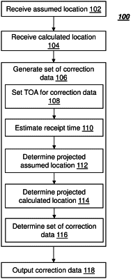
1. A method performed using circuitry for providing corrections for a Global Navigation Satellite System (GNSS), the method comprising:
receiving an assumed location of a Global Navigation Satellite System (GNSS) satellite including both time and position data;
calculating the actual location of the GNSS satellite including both time and position data;
generating a set of correction data based on an error between the assumed location and the calculated location of the GNSS satellite including:
setting a time of applicability (TOA) of the set of the correction data;
estimating a receipt time of the set of the correction data by a user;
determining a projected assumed location of the GNSS satellite at the receipt time;
determining a projected calculated location of the GNSS satellite at the receipt time; and
determining the set of the correction data, such that the error is minimized when the set of the correction data is quantized and applied to the projected assumed location at the receipt time to generate a projected corrected location at the receipt time;
wherein the location error is based on a difference between the projected corrected location at the receipt time and the projected calculated location at the receipt time; and
outputting the set of the correction data.
|