| CPC G06T 7/521 (2017.01) [G01S 17/931 (2020.01); G05D 1/024 (2013.01); G05D 1/0212 (2013.01); G06N 20/00 (2019.01); G06T 7/11 (2017.01); G06T 7/77 (2017.01); G06T 2207/20081 (2013.01); G06T 2207/30261 (2013.01)] | 20 Claims |
|
1. A method comprising:
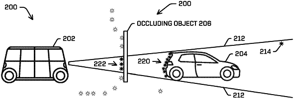
receiving LIDAR data and image data associated with an environment;
determining, based at least in part on the image data, a region of interest identifying a portion of the image data as being associated with an object in the environment;
generating scores for LIDAR points associated with the region of interest, wherein generating a first score of the scores for a corresponding first LIDAR point is based, at least in part, on a distance from a first point in the image data within the region of interest to a second point in the image data associated with a projection of the first LIDAR point into the image data, and wherein the first score is non-binary;
determining, based at least in part on the scores, a weighted median of the LIDAR points; and
determining, based at least in part on the weighted median, a first depth estimate associated with a distance from a sensor to the object.
|