| CPC G05D 1/106 (2019.05) [B64C 39/024 (2013.01); B64U 20/80 (2023.01); B64U 2101/20 (2023.01); B64U 2201/10 (2023.01); G01S 19/073 (2019.08)] | 20 Claims |
|
1. A method for controlling an unmanned aerial vehicle, applicable to an application scenario without a pre-disposed reference base station, the method comprising:
obtaining, in a process of flying along a target course sent by a first ground station, first positioning auxiliary information sent by the first ground station, the target course being used for instructing the unmanned aerial vehicle to fly from a first location point to a second location point, the target course being generated through the first ground station according to the first location point and the second location point, the first location point being determined through the first ground station, and the second location point being determined through a second ground station, wherein
the first ground station is configured to receive positioning information of the unmanned aerial vehicle at a first location and determine the first location point, the positioning information of the unmanned aerial vehicle at the first location being obtained through positioning by a real-time kinematic module in the unmanned aerial vehicle; the second ground station is configured to perform positioning at a second location, obtain the second location point, and send the second location point to the first ground station, so that the first ground station generates the target course according to the second location point and the first location point; and is configured to send second positioning auxiliary information to the unmanned aerial vehicle when moving from the second location point to a fixed location point within a preset region range; the first ground station is configured with a real-time kinematic module, and the second ground station is configured with a real-time kinematic module; the first ground station performs positioning through the real-time kinematic module working in a base mode, and sends the first positioning auxiliary information through the real-time kinematic module working in a rover mode; the second ground station performs positioning through the real-time kinematic module working in the base mode, and sends the second positioning auxiliary information through the real-time kinematic module working in the rover mode; and the first ground station and the second ground station communicate in a manner of mobile communication;
obtaining first positioning information, and correcting the first positioning information according to the first positioning auxiliary information, to convert the first positioning information into positioning information in a reference coordinate system of the first ground station, the target course being a course generated through the first location point in the reference coordinate system established by the first ground station and the second location point in the reference coordinate system established by the first ground station;
adjusting a flight attitude according to the corrected first positioning information and the target course, to fly along the target course;
in a case of determining that a ground station switching condition of the second ground station is satisfied, stopping flying, hovering at a current location point, and obtaining the second positioning auxiliary information sent by the second ground station;
obtaining second positioning information, and correcting the second positioning information according to the second positioning auxiliary information, to convert the second positioning information into positioning information in a reference coordinate system of the second ground station;
adjusting the flight attitude according to the corrected second positioning information and the target course, all flight points of the target course at a current moment being coordinate locations in the reference coordinate system established by the second ground station, and the target course being switched from flying from the first location point in the reference coordinate system established by the first ground station to the second location point in the reference coordinate system established by the first ground station to flying from the first location point in the reference coordinate system established by the first ground station to the current location point, and flying from the current location point to the second location point in the reference coordinate system established by the second ground station; and
ending the hovering, and continuing to fly in an adjusted flight direction, to fly along the target course to reach the second location point, the first ground station and the second ground station comprising mobile terminals, the first positioning auxiliary information comprising real-time kinematic data, and the second positioning auxiliary information comprising real-time kinematic data,
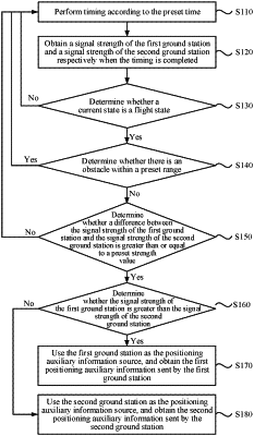
the determining that a ground station switching condition of the second ground station is satisfied comprising:
obtaining a signal strength of the first ground station and a signal strength of the second ground station, and determining a target ground station with a higher signal strength; and
determining that the ground station switching condition of the second ground station is satisfied in a case of determining that the target ground station is the second ground station.
|