| CPC H04N 13/243 (2018.05) [G06F 18/2415 (2023.01); G06T 7/593 (2017.01); G06V 10/764 (2022.01); G06V 20/188 (2022.01); G06V 20/38 (2022.01); H04N 13/128 (2018.05); H04N 13/204 (2018.05); H04N 13/239 (2018.05); H04N 13/271 (2018.05); G06T 2207/10021 (2013.01); G06T 2207/20076 (2013.01); G06T 2207/20081 (2013.01); G06T 2207/30252 (2013.01); G06V 2201/12 (2022.01); H04N 2013/0081 (2013.01); H04N 2013/0092 (2013.01)] | 20 Claims |
|
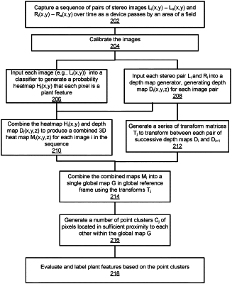
1. A method for generating a combined depth map representing at least a portion of a field comprising a plurality of plants:
accessing, from an image acquisition system of a farming machine travelling through the field, a plurality of images of the field, each image including pixels comprising information describing plants in the image, and distances between objects in the field and the farming machine;
classifying, using a plant identification model, pixels in the plurality of images as plants of the plurality of plants;
generating, using a depth map generation model and classified plants in the plurality of images, a plurality of depth maps quantifying distances between classified plants and the farming machine;
combining the plurality of depth maps into a combined depth map spatially locating classified plants in the field, the combined depth map comprising a plant cluster comprising spatially proximal plants identified between two or more of the depth maps of the plurality;
determining the plant cluster is an individual plant of the plurality of plants based on a spatial proximity of plants in the plant cluster and modifying the combined depth map such that the plant cluster is represented as the individual plant in the combined depth map; and
treating at least one of the plurality of plants in the field based on locations of plants in the combined depth map.
|