| CPC G06V 20/64 (2022.01) [G05D 1/027 (2013.01); G05D 1/0221 (2013.01); G05D 1/0238 (2013.01); G05D 1/0251 (2013.01); G06F 18/24147 (2023.01); G06T 7/74 (2017.01); G06V 20/10 (2022.01); G06V 20/58 (2022.01); G05D 2201/0203 (2013.01); G06T 2207/10028 (2013.01)] | 14 Claims |
|
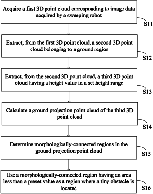
1. A method for detecting small obstacles, applied to a cleaning robot and being implemented by a processor in the cleaning robot, the method comprising steps of:
acquiring a first 3D point cloud corresponding to image data acquired by the cleaning robot and first inertial measurement unit data collected by one or more sensors of the cleaning robot;
extracting, from the first 3D point cloud, a second 3D point cloud of a ground region;
extracting, from the second 3D point cloud, a third 3D point cloud having a height value in a set height range, wherein the set height range is a range containing a positive and/or a negative range;
calculating a ground projection point cloud of the third 3D point cloud;
determining morphologically-connected regions in the ground projection point cloud; and
using a morphologically-connected region having an area less than a preset value as a region where a small obstacle is located;
wherein an approach to acquire 3D point cloud data contains: an RGB depth image is acquired by an RGBD camera arranged on the cleaning robot, a depth image is extracted from the RGB depth image, and coordinate transformation is performed on the depth image to obtain the first 3D point cloud; or the first 3D point cloud of the cleaning robot is remotely received through wireless communication;
wherein the extracting, from the first 3D point cloud, a second 3D point cloud of a ground region comprises:
obtaining plane information by one of the following:
(i) searching, in a mapping set, second inertial measurement unit data closest to the first inertial measurement unit data; determining plane information corresponding to the second inertial measurement unit data according to the mapping set; wherein the mapping set is constructed according to historical second inertial measurement unit data of the cleaning robot during operation and corresponding plane information, and the mapping set comprises a mapping relationship between the historical second inertial measurement unit data and the plane information; or
(ii) training a learning model by using a training data set to obtain a first model;
wherein training input data and training output data in one-to-one correspondence in the training data set are respectively inertial measurement unit data and plane information corresponding to ground data in a 3D point cloud acquired by the cleaning robot at a same historical moment, respectively;
inputting the first inertial measurement unit data into the first model to obtain plane information output by the first model;
wherein the extracting, from the first 3D point cloud, a second 3D point cloud of a ground region further comprises:
extracting, from the first 3D point cloud, a second 3D point cloud of a ground region, according to the plane information;
wherein the plane information is used for indicating a plane in a world coordinate system.
|