| CPC B60G 17/0165 (2013.01) [B64C 39/024 (2013.01); G06T 19/006 (2013.01); G08G 5/0086 (2013.01); B64U 2101/30 (2023.01)] | 15 Claims |
|
1. A method comprising:
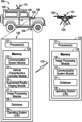
receiving, by a computer of a vehicle and from an unmanned aerial vehicle (UAV) in communication with the vehicle, at least a first image of a first section of a ground surface;
capturing, by an imaging system of the vehicle, at least a second image of a second section of the ground surface located below the vehicle, the second image including at least a part of the first section of the ground surface;
generating, by the computer and based on the first image and the second image, terrain information of the ground surface;
modifying, by the computer and based the terrain information, at least one driving characteristic of the vehicle;
spatially matching the first image to the second image by identifying at least a first topographic feature that is present in each of the first image and the second image;
generating a first topographic representation of the first image and a second topographic representation of the second image, wherein the first topographic representation includes the first topographical feature and the second topographic representation includes the first topographical feature;
spatially aligning the first topographic representation of the first image with the second topographic representation of the second image based on a location of the first topographic feature in the first topographic representation and a location of the first topographic feature in the second topographic representation;
determining, by the computer located in the vehicle, at least one of an angular orientation of a chassis of the vehicle with respect to the ground surface and an angle of a wheel of the vehicle with respect to the chassis of the vehicle;
generating, based on spatially aligning the first topographic representation to the second topographic representation and by the computer located in the vehicle, an augmented reality image that combines a contour of a part of the vehicle and a rendering of a terrain area below the vehicle including a combined topographic representation based on the first topographic representation and the second topographic representation; and
displaying the augmented reality image on a display of an infotainment system in the vehicle, wherein the contour of the part of the vehicle is a semi-transparent top-down representation of the vehicle that includes an outline of a chassis of the vehicle and wheels of the vehicle, and wherein a portion of the rendering of the terrain located behind the contour in the augmented reality image is visible through the contour.
|