| CPC G01N 24/081 (2013.01) [E21B 49/003 (2013.01); G01N 33/24 (2013.01); G01R 33/46 (2013.01); E21B 2200/20 (2020.05)] | 20 Claims |
|
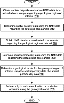
1. A method, comprising:
obtaining, by a computer processor, first nuclear magnetic resonance (NMR) data for a saturated core sample regarding a geological region of interest;
determining, by the computer processor and using the first NMR data, spatial porosity data based on the saturated core sample, wherein the spatial porosity data describes a plurality of porosity values as a function of a sampling position of the saturated core sample;
obtaining, by the computer processor, second NMR data for a desaturated core sample regarding the geological region of interest;
determining, by the computer processor and using the second NMR data, spatial permeability data based on the desaturated core sample, wherein the spatial permeability data describes a plurality of permeability values as a function of the sampling position of the desaturated core sample; and
determining, by the computer processor, a geological model for the geological region of interest using the spatial porosity data, the spatial permeability data, and a fitting process.
|