| CPC A01B 79/005 (2013.01) [G01N 1/02 (2013.01); G01N 33/24 (2013.01); G06F 3/0482 (2013.01); G06Q 50/02 (2013.01); G01N 2001/021 (2013.01); G01N 2033/245 (2013.01)] | 16 Claims |
|
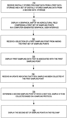
1. A computer-implemented method of tracking soil sampling in a field, comprising:
receiving digitally stored field map data from a first data storage source and digitally stored historical sampling data from a second data storage source, wherein the historical sampling data is indicative of at least one soil physical characteristic;
based on the field map data and the historical sampling data, in a computer-generated graphical user interface, displaying a graphical map of an agricultural field comprising a first set of sampling points, each sampling point of the first set of sampling points being assigned to a corresponding section in the field map that is associated with a corresponding geographic coordinate;
receiving a selection of a first sampling point of the first set of sampling points;
displaying, in the computer-generated graphical user interface, first sampling data that is associated with the first sampling point, the first sampling data comprising a set of soil physical characteristics and a set of order data of the first sampling data, the set of soil physical characteristics including at least one of a pH level, acidity, macronutrients, and/or micronutrients, and the set of order data of the first sampling data including at least one of a sampled date, a shipment date, a collector identification, and/or a sampling protocol;
receiving an update to the set of order data, the update indicating that a soil sample has been collected at the first sampling point;
based on the received update:
retrieving laboratory data identifying one or more available testing facilities that are capable of testing the soil sample, the laboratory data being linked to the field map;
displaying, in the computer-generated graphical user interface, the one or more available testing facilities;
receiving a selection of a particular testing facility from among the one or more available testing facilities via the computer-generated graphical user interface;
transmitting the updated set of order data of the first sampling data to a computer of the selected testing facility over a network; and
highlighting, in the field map, the first sampling point to visually depict the first sampling point differently from other ones of the first set of sampling points;
determining a second sampling point at which a next soil sample is to be collected based on a sampling protocol; and
displaying the second sampling point in the field map, the second sampling point being depicted using visually different attributes compared to the first sampling point;
wherein the method is performed using one or more computing devices.
|