| CPC H04W 64/003 (2013.01) [H04W 84/18 (2013.01)] | 20 Claims |
|
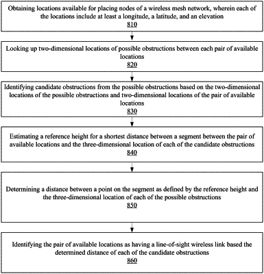
1. A method comprising:
obtaining locations available for placing nodes of a wireless mesh network, wherein the locations include at least a longitude, a latitude, and an elevation;
for pairs of available locations,
looking up two-dimensional locations of possible obstructions between a pair of available locations;
identifying candidate obstructions from the possible obstructions based on the two-dimensional locations of the possible obstructions and two-dimensional locations of the pair of available locations;
estimating a reference height associated with a shortest distance between a segment between the pair of available locations and a three-dimensional location of the candidate obstructions;
determining a distance between a point on the segment as defined by the reference height and the three-dimensional location of the possible obstructions; and
identifying the pair of available locations as having a line-of-sight wireless link based on the determined distance of the candidate obstructions.
|