| CPC G06V 20/647 (2022.01) [G01S 17/42 (2013.01); G06T 7/11 (2017.01); G06T 11/203 (2013.01); G06V 10/25 (2022.01); G06T 2207/10028 (2013.01); G06T 2207/20081 (2013.01); G06T 2210/12 (2013.01)] | 34 Claims |
|
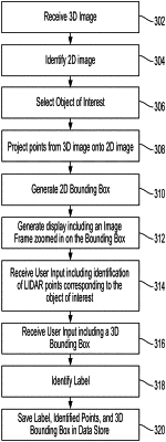
1. A method for processing point cloud data, the method comprising:
receiving a 3D image comprising point cloud data;
displaying, on a user interface, a 2D image associated with the 3D image;
generating a 2D bounding box that envelops an object of interest in the 2D image;
generating an image frame for identification of one or more points in the point cloud data as being associated with the object of interest based on a user's interaction with the image frame, the generating comprising:
generating, by projecting a plurality of points in the 3D image on the 2D image in a first direction, a first projected image frame comprising a first projected plurality of points;
displaying, on the user interface, the image frame that comprises the 2D image and the 2D bounding box superimposed by the first projected image frame;
receiving a first user input comprising a selection of a set of points in the first projected plurality of points that correspond to the object of interest;
identifying a label for the object of interest; and
storing, in a data store, the set of points that correspond to the object of interest in association with the label.
|