US 11,756,157 B2
Multimodal inspection system
Anthony George, Columbus, OH (US); Thomas Kent, Columbus, OH (US); Blaine Miller, Columbus, OH (US); Katie Liszewski, Columbus, OH (US); Russell Gilabert, Columbus, OH (US); and Timothy McDonley, Columbus, OH (US)
Assigned to BATTELLE MEMORIAL INSTITUTE, Columbus, OH (US)
Filed by Battelle Memorial Institute, Columbus, OH (US)
Filed on Mar. 29, 2021, as Appl. No. 17/216,304.
Claims priority of provisional application 63/001,009, filed on Mar. 27, 2020.
Prior Publication US 2022/0020114 A1, Jan. 20, 2022
Int. Cl. G06T 11/60 (2006.01); G06T 3/40 (2006.01); G01S 17/86 (2020.01); G01S 13/86 (2006.01); G01S 13/89 (2006.01); G01S 17/89 (2020.01); G06T 3/00 (2006.01)
CPC G06T 3/4038 (2013.01) [G01S 13/865 (2013.01); G01S 13/89 (2013.01); G01S 17/86 (2020.01); G01S 17/89 (2013.01); G06T 3/0068 (2013.01)] 20 Claims
OG exemplary drawing
 
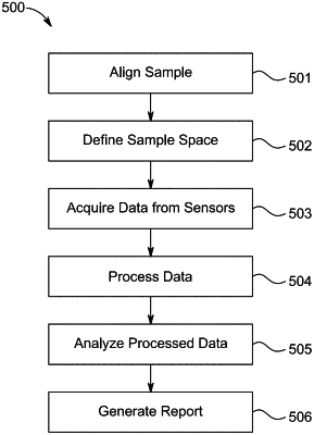
1. A method comprising:
capturing data from a plurality of sensors over a period of time to generate a set of captured data for each sensor of the plurality of sensors;
capturing location information for each sensor of the plurality of sensors;
performing spatial correlation on each set of captured data using in part the location information;
analyzing the spatially correlated data for an anomaly; and
generating a report regarding the anomaly based on the analyzed data.