| CPC G06Q 50/06 (2013.01) [G06F 16/954 (2019.01); G06Q 30/0283 (2013.01); G06Q 30/04 (2013.01)] | 2 Claims |
|
1. A method for automatically modifying per-parcel stormwater utility fees for parcels in a municipality, comprising the steps of:
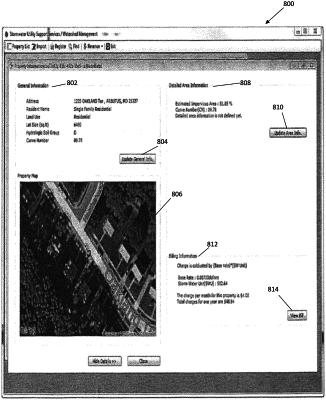
collecting, at one or more data storage devices, parcel record data for parcels in a municipality from a remote, publicly accessible data source, wherein the parcel record data comprises a lot size, a location, a land use type, a hydrologic soil group, a Curve Number, a property map, billing information, and parcel change data including historical impervious surface area data for each of the parcels;
sending said parcel record data from said one or more data storage devices to a processor;
generating, by the processor, a real-time model of the parcels in the municipality, wherein an output of the real-time model is an estimate of municipality average impervious surface area using said parcel record data by:
determining, by the processor, an initial Curve Number for each parcel of a plurality of parcels in said parcel record data;
determining, by the processor, an expanded range of Curve Number values for said plurality of parcels in said parcel record data by interpolating parcel area, impervious surface area, and impervious percentage of said initial Curve Numbers;
determining, by the processor, a relationship of Curve Number to lot size for said plurality of parcels;
performing, by the processor, linear regression analysis of data indicating said relationship of Curve Number to lot size for said plurality of parcels; and
establishing, by the processor, a customized stormwater unit equal to a product of the Curve Number and the lot size for said plurality of parcels;
generating, by the processor, a per-parcel stormwater utility fee based on the estimate of municipality average impervious surface area by:
summing, by the processor, established, customized stormwater units for each parcel of said plurality of parcels; and
dividing, by the processor, a total target revenue by said sum of the established, customized stormwater units for said plurality of parcels;
transmitting, from said processor to a remote stormwater utility computing device,. an interactive electronic page, and engaging said remote stormwater utility computing device through said interactive electronic page with said processor to calculate at least one of (i) a total stormwater utility fee revenue based on a total number of stormwater units for the parcels in said municipality and an established rate, and (ii) a rate based on said total number of stormwater units for the parcels in said municipality and a target total stormwater utility fee revenue, wherein the interactive electronic page displays an aerial image associated with the product map of at least one parcel of the plurality of parcels;
monitoring, by said processor, a computer associated with the at least one parcel of the plurality of parcels, to detect implementation by said computer associated with the at least one parcel of the plurality of parcels of a stormwater mitigation product, wherein the implementation is detected by monitoring for at least one of a completed mitigation transaction by a remote third-party provider of the stormwater mitigation product, a change in an application of a stormwater-impacting product, or a change to the aerial image; and
upon detection of the implementation by said computer associated with the at least one parcel of the plurality of parcels of a stormwater mitigation product:
causing said remote stormwater utility computing device to request updated parcel record data;
modifying, by the processor, the real-time model;
updating, by the processor, the estimate of municipality average impervious surface area; and
automatically generating, at said processor, an updated per-parcel stormwater utility fee associated with the at least one parcel of the plurality of parcels.
|