| CPC G01V 1/307 (2013.01) [G01V 1/36 (2013.01); G01V 2210/23 (2013.01)] | 15 Claims |
|
1. A computer-implemented method, comprising:
accessing a set of seismic traces from a grid of locations inside an geo-exploration area, each seismic trace records seismic reflections from underneath the geo-exploration area at a location of the grid;
accessing an input surface indicating more than one stratigraphic surfaces in the set of seismic traces;
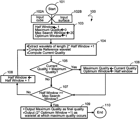
extracting a plurality of wavelets from the set of seismic traces, each wavelet covering an variable length around the input surface of a corresponding seismic trace;
determining a reference wavelet for each wavelet of a corresponding variable length;
quantifying a respective quality of each of the more than one stratigraphic surfaces based on correlating the plurality of wavelets with each reference wavelet of the corresponding variable length;
ranking the more than one stratigraphic surfaces based on the respective quality of each of the more than one stratigraphic surface surfaces; and
based on the ranked more than one stratigraphic surfaces, providing a feedback to a selection process for the more than one stratigraphic surfaces such that the selection process is iteratively improved based on the feedback, wherein the selection process includes at least one of: an artificial intelligence (AI) algorithm, a machine learning (ML) algorithm, or a dynamic programming algorithm, and wherein when a quality of a first stratigraphic surface is compared with a quality of a second stratigraphic surface that is deeper than the first stratigraphic surface, a conformity of the first stratigraphic surface and the second stratigraphic surface is automatically determined, thereby estimating geological activities happening between when the first stratigraphic surface is deposited and when the second stratigraphic surface is deposited.
|