| CPC B64C 39/024 (2013.01) [G05D 1/0094 (2013.01); G06Q 50/26 (2013.01); G08B 25/001 (2013.01); G08B 25/08 (2013.01); G08B 29/185 (2013.01); B64U 2101/30 (2023.01); B64U 2101/31 (2023.01); B64U 2201/10 (2023.01); G06T 2207/30232 (2013.01); G08B 13/19695 (2013.01)] | 20 Claims |
|
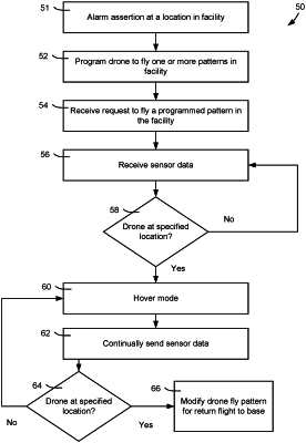
1. A method of aerial surveillance, comprising:
receiving, by a computer system from a building management system (BMS), an alarm condition;
programming, by the computer system, a drone with at least a portion of a map including a route between a starting point and a location of interest, the map comprising a data structure representation of a plurality of radio-frequency (RF) devices
wherein the drone navigates to the location of interest by determining its position on the route using signals from the plurality of RF devices; and
sending, by the drone, to the computer system, sensor data in response to arriving at the location of interest.
|