| CPC G06T 7/001 (2013.01) [G01C 9/06 (2013.01); G06T 7/13 (2017.01); G06T 7/60 (2013.01); G06T 17/20 (2013.01); G06T 2200/08 (2013.01); G06T 2207/10012 (2013.01); G06T 2207/10028 (2013.01); G06T 2207/20081 (2013.01); G06T 2207/20084 (2013.01); G06T 2207/30108 (2013.01); G06T 2210/56 (2013.01)] | 6 Claims |
|
1. A joint surface safety evaluation apparatus comprising:
one or more processors;
a memory coupled to the one or more processors and configured to store instructions, which, when executed by the one or more processors, causes the one or more processors to perform operations comprising:
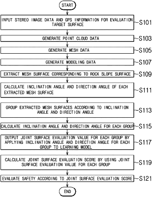
receiving stereo image data from a stereo vision camera and GPS information generated as an evaluation target surface from a GPS information collection device is captured from the outside to generate point cloud data constituted by a plurality of coordinates having a depth estimated from the stereo image data and a coordinate value corresponding to the evaluation target surface based on the GPS information;
generating mesh data constituted by a combination of a plurality of polygonal mesh surfaces from the point cloud data, and generating modeling data by overlapping the stereo image data and the mesh data;
extracting a mesh surface corresponding to a rock slope surface by applying the modeling data to a learning model pre-learned by using a plurality of images including the rock slope surface and supervised learning values for an area corresponding to the rock slope surface in each of the plurality of images;
calculating a joint surface evaluation score based on an evaluation value output by grouping the plurality of extracted mesh surfaces by using a normal vector for each of the plurality of mesh surfaces, calculating an inclination angle and a direction angle for each group, and applying the inclination angle and the direction angle for each group to the pre-learned learning model so as to output evaluation values for the inclination angle and the direction angle;
detecting a boundary by receiving the stereo image data, and extracting a plurality of boundary coordinates which are coordinates corresponding to the detected boundary among the plurality of coordinates of the point cloud data;
electing and outputting any one of a first classification value corresponding to a crack or a second classification value corresponding to a non-crack by applying the stereo image data to the pre-learned learning model so as to discriminate the crack or the non-crack by receiving the stereo image data;
calculating each of a length and a width of the crack by using the plurality of boundary coordinates when the first classification value is output;
outputting a crack evaluation value by applying the length and the width of the crack to the pre-learned learning model so as to output the crack evaluation value for the length and the width of the crack by receiving the length and the width of the crack; and
selecting and outputting any one of a plurality of predetermined safety degrees according to a value acquired by summing the crack evaluation value and the joint surface evaluation score.
|