| CPC G06Q 40/08 (2013.01) [G01N 33/0075 (2013.01); G01W 1/00 (2013.01)] | 17 Claims |
|
1. A method comprising:
receiving, by a computing device having one or more processors and from a user device, a request for generating a neighborhood safety assessment, wherein the request is based on at least an environmental parameter and a social parameter;
determining, by the computing device and based on global positioning system (GPS) data of the user device, a desired geographic area for the neighborhood safety assessment, the desired geographic area comprising a vicinity defined within a radius span of the user device based on the GPS data;
determining, by the computing device, the radius span of the vicinity as being associated with and defining a neighborhood, the neighborhood identified based on the GPS data of the user device;
determining, by the computing device, one or more environmental sensors associated with the desired geographic area;
causing, by the computing device in real time, one or more environmental sensors to generate a present value for the environmental parameter;
receiving, by the computing device and from a second device associated with the desired geographic area, an insurance report based on the neighborhood as defined by the radius span and identified based on the GPS data of the user device;
processing, via one or more natural language processors of the computing device, one or more terms of the insurance report to identify a value of the social parameter;
generating, by the computing device executing logic via a safety parameter assessment engine comprising a machine learning algorithm trained to generate the neighborhood safety assessment based on the present value for the environmental parameter and based on the value of the social parameter, the neighborhood safety assessment for the desired geographic area; and
training the machine learning algorithm to generate the neighborhood safety assessment based on at least past environmental data, wherein training comprises:
acquiring a training data set, including at least past environmental data from a database associated with the one or more environmental sensors, for the machine learning algorithm to be trained;
generating with the training data, feature vectors, wherein each feature vector includes (1) the past environmental data received within a predetermined period of time, and (2) the temporal and geographical information for each of the received past environmental data; and
associating each of the feature vectors with current environmental data;
generate one or more feature weights corresponding to an effect of the past environmental data on the current environmental data at a given location and a given time;
training the machine learning algorithm using the associated feature vectors and the one or more feature weights;
store results of the machine learning algorithm, including the one or more feature weights;
wherein the neighborhood safety assessment comprises:
a first score for neighborhood safety based on the social parameter,
a second score for neighborhood safety based on the environmental parameter,
a third score for neighborhood safety based on a holistic assessment of the social parameter and the environmental parameter, and
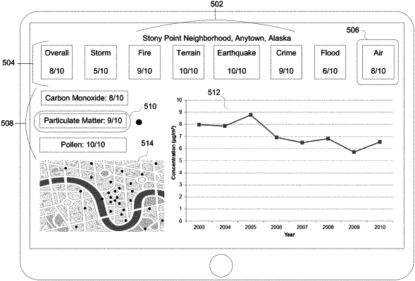
a visual spatial representation of the social parameter and the environmental parameter, the visual spatial representation comprising a display on a user interface of (i) a map of the desired geographic area, (ii) an indicator of at least one of the social parameter and the environmental parameter overlaid on the map, wherein the indicator is associated with a selection of the at least one of the social parameter and the environmental parameter, and (iii) the first score, the second score, and the third score of the neighborhood safety assessment.
|