| CPC G01S 13/9023 (2013.01) [G01V 3/12 (2013.01); G01V 3/38 (2013.01); G06T 1/20 (2013.01); G06T 1/60 (2013.01); G06T 3/20 (2013.01); G06T 7/11 (2017.01); G06T 7/593 (2017.01); G06T 17/05 (2013.01)] | 22 Claims |
|
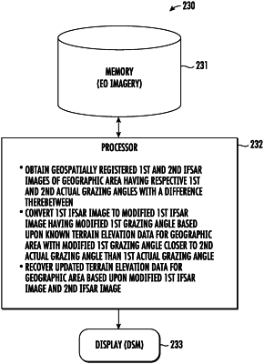
1. A system comprising:
a memory and a processor cooperating therewith to
obtain geospatially registered first and second interferometric synthetic aperture radar (IFSAR) images of a geographic area having respective first and second actual grazing angles with a difference therebetween,
convert the first IFSAR image to a modified first IFSAR image having a modified first grazing angle based upon known terrain elevation data for the geographic area, the modified first grazing angle being closer to the second actual grazing angle than the first actual grazing angle, and
recover updated terrain elevation data for the geographic area based upon the modified first IFSAR image and the second IFSAR image.
|