| CPC G01C 21/3819 (2020.08) [B60W 10/04 (2013.01); B60W 10/10 (2013.01); B60W 10/18 (2013.01); B60W 10/20 (2013.01); G01C 21/3833 (2020.08); B60W 2552/05 (2020.02); B60W 2552/30 (2020.02); B60W 2552/53 (2020.02); B60W 2556/40 (2020.02); B60W 2556/45 (2020.02); B60W 2710/1005 (2013.01); B60W 2710/18 (2013.01); B60W 2710/20 (2013.01); B60W 2720/106 (2013.01); B60W 2720/125 (2013.01); G05D 1/0212 (2013.01)] | 3 Claims |
|
1. A method for controlling a vehicle, comprising:
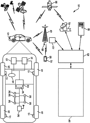
receiving, by a controller, perception input data from a sensor of the vehicle;
receiving, by the controller, map data including road lane information in a vicinity of the vehicle;
processing, by the controller, the perception input data to extract perceived road lane information including a perceived x position, a perceived y position, a perceived z position, a perceived lane type, a perceived lane color, and a perceived lane curvature;
processing, by the controller, the map data to extract map road lane information including a map x position, a map y position, a map z position, a map lane type, a map lane color, and a map lane curvature;
calculating, by the controller, a transformation matrix from the perceived road lane information, including perceived x position, perceived y position, perceived z position, perceived lane type, perceived lane color, and perceived lane curvature, and the map road lane information, including perceived x position, perceived y position, perceived z position, perceived lane type, perceived lane color, and perceived lane curvature;
generating, by the controller, a fitness score evaluating an effectiveness of the transformation matrix;
updating, by the controller, the map data and a localization of the vehicle based on the transformation matrix; and
generating, by the controller, a control signal to control an actuator of the vehicle;
wherein calculating the transformation matrix comprises determining a distance d between a first sample point from the perception input data and a second sample point from the map data using an equation
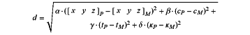 where [x Y z]P, cP, tP, and κP are the perceived x position, perceived y position, perceived z position, perceived lane color, perceived lane type, and perceived lane curvature for a perception input data sample point;
[x y z]M, cM, tM, κM are the map x position, map y position, map z position, map lane color, map lane type and map lane curvature for a map data sample point; and
α,β, γ, and δ are corresponding weight factors.
|