| CPC B60W 30/06 (2013.01) [G01C 21/3682 (2013.01); G01C 21/3685 (2013.01); G01C 21/3811 (2020.08); H04W 4/021 (2013.01)] | 15 Claims |
|
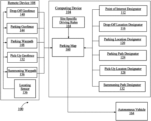
1. A method of mapping a parking area for autonomous parking, the method comprising:
receiving, using a computing device, a point of interest designator for a point of interest, a drop-off location designator for a drop-off location associated with the point of interest, a parking location designator for a parking location associated with the point of interest, and a parking path designator for a parking path between the drop-off location and the parking location;
validating, using the computing device, a remote device having at least a locating sensor as a function of a surveyor identifier comprising at least an element of data configured to uniquely identify the remote device, wherein the remote device is configured to record survey data;
receiving, using the computing device, the survey data of the point of interest from the remote device as a function of validating the remote device, wherein the survey data comprises:
a drop-off geofence for the drop-off location;
a parking geofence for the parking location;
a parking waypath for the parking path; and
site-specific driving rules associated with the point of interest;
generating, using the computing device, a parking map for the point of interest, wherein the parking map comprises the drop-off location designator, the parking location designator, the parking path designator, the drop-off geofence, the parking geofence, the parking waypath, and the site-specific driving rules;
verifying, using the computing device, the survey data, as a function of a machine-learning model, wherein the machine learning model is trained with training data correlating survey data to survey data classifications; and
validating, using the computing device, the parking waypath, wherein validating the parking waypath further comprises:
segmenting the parking waypath into a plurality of parking sub-waypaths; and
validating at least a parking sub-waypath of the plurality of parking sub-waypaths.
|