| CPC A01B 79/005 (2013.01) [G06F 16/2458 (2019.01); G06F 16/29 (2019.01); G06N 3/08 (2013.01); G06V 10/764 (2022.01); G06V 20/13 (2022.01); G06V 20/188 (2022.01)] | 10 Claims |
|
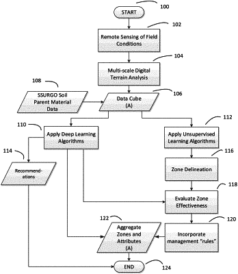
1. A system for optimizing agricultural soil zone attributes comprising:
a data processor in communication with a data server;
a user device capable of displaying data representations to a user;
a first dataset constructed from remote sensing and digital analysis;
a second dataset constructed from collected imagery bands and calculated indices;
a third dataset constructed from a combination of inputs to the first dataset and the second dataset;
wherein the data processor applies artificial intelligence algorithms to the first dataset and outputs a first set of soil zone attributes;
wherein the data processor applies artificial intelligence algorithms to the second dataset and outputs a second set of soil zone attributes;
wherein the data processor applies artificial intelligence algorithms to the third dataset and outputs a third set of soil zone attributes;
wherein the data processor compares the first, second, and third sets of soil zone attributes;
wherein the data processor creates preliminary zone boundaries from the first, second, and third sets of soil zone attributes by (1) maximizing a total number of statistically different soil zone attributes, (2) maximizing inter-zone differences between soil zone attributes, and (3) minimizing within-zone variances;
wherein the data processor calculates a change in at least one set of soil zone attributes from an aggregated zone comprised of the preliminary zone and one or more zone patches and/or inclusions;
wherein the data processor dissolves zone boundaries of the preliminary zone and the one or more zone patches and/or inclusions; and
wherein the data processor delivers an optimized set of soil zone attributes and one or more zone management recommendations to the user.
|